


The Victorian Department of Energy, Environment and Climate Action (DEECA) and Tonkin + Taylor have come together for an innovative study of Victoria’s coastline, which will enable the proactive management of coastal cliffs now and into the future.
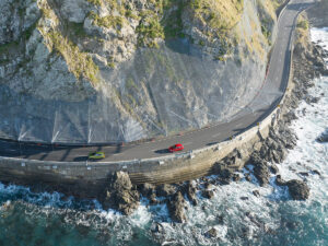
Coastal cliffs are dynamic by nature, constantly eroding due to natural processes such as wind and wave action, drainage and overland flow and chemical weathering. The distinctive features of the Victorian coastline are created by the complex interaction between the various geological units and coastal processes to create landforms that support a diversity of cultural, environmental, social and economic values.
However, accelerated climate change, including the consequent rise in sea levels, poses a significant risk to coastal cliffs and their associated ecosystems and infrastructure. Proactive risk management is therefore essential to ensure these natural and man-made coastal assets can be enjoyed by future generations.
After a competitive tendering process, Tonkin + Taylor was selected by DEECA to undertake a study of coastal cliffs along the entire Victorian coastline. The purpose of the study was to provide an understanding of coastal risks at a regional level, to support local land managers in undertaking their role, and to identify areas requiring detailed local assessments. Tonkin + Taylor was well positioned to deliver this complex package of work at the scale required, having a skilled team of coastal engineers and engineering geologists with a proven track record of similar studies.
The work involved assessing the various geological units and coastal processes to determine cliff areas susceptible to inundation and erosion, as well as talus runout, in the even that instability occurred. Melbourne-based Tonkin + Taylor Associate Engineering Geologist Wendy Greatbatch helped lead the cliff instability assessment work.
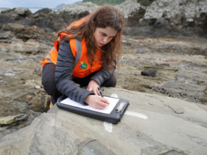
“Projects like this, where you are dealing with a wide range of geologies and considering the effects on a regional scale, are very rare, and make for a very exciting project,” said Ms Greatbatch. With an understanding of the Victorian geological units and their weathering behaviour, Ms Greatbatch was able to divide the coastline into component areas which could be expected to have a similar response to coastal processes. This was validated through a series of “ground-truthing” site visits to ensure assumptions made during the desk study were accurate.
The study included complex GIS analysis of historic and recent aerial imagery, augmented by aerial reconnaissance of the entire coastline. Reconnaissance by a small fixed-wing aircraft provided additional detail on coastal processes, allowed further validation of the assessment approach, and provided DEECA with a repository of thousands of up-to-date high-resolution images at a scale not previously available.
By combining disparate information from multiple sources, Tonkin + Taylor assessed past, present and future erosion rates under different sea-level change scenarios. The information was then used to inform a “second-pass” risk assessment focussed on public assets and safety.
The work carried out by Tonkin + Taylor provides a valuable building block on which future detailed studies at a local scale can be undertaken, as well as providing a record of the current coastal cliff conditions at a scale not previously available. The work is intended to help land managers engage with their local community and to proactively manage their unique coastal assets.
(This article was originally published in the March edition of Infrastructure magazine.)